What If Disasters Maps Guide
A good What If Disasters map strategy starts with recognition, not a memorized path. When the countdown ends, read the displayed map name and use the most obvious landmark to orient yourself. Then choose a destination that matches the disaster: high ground for rising water, solid shelter for falling debris, and an open route when buildings or roads are becoming dangerous. Once oriented, use the survival guide to match that terrain to the active prompt.
The important rule is to treat a map as changing terrain. A bridge, road, building, or tall attraction can be useful in one round and dangerous in the next. The guide below separates confirmed landmarks from locations that are only described in the available records, so you do not mistake a video callout for a guaranteed permanent map layout.
How to recognize maps quickly
Use this short routine during the map reveal:
- Read the map name after the countdown finishes.
- Scan for a landmark you can see immediately, such as a Ferris wheel, lighthouse, bridge, large building, or dam.
- Mark the nearest high point and the nearest covered space before the disaster begins.
- Identify at least one alternate route. Roads can split, buildings can fall, and water can cut off a low area.
- Re-check the ground after the disaster starts instead of following the original route blindly.
The evidence does not provide a complete formal map roster or fixed spawn-point list. That makes visible confirmation more reliable than assuming that a named location always appears in the same place or has the same safe route.
Known maps and landmark roles
| Map or location | What to look for | Best first decision | Important limit |
|---|---|---|---|
| Thrill Park | Ferris wheel, central tall ride, Haunted house, roadside tower, and streets | Use the landmarks to orient yourself, then choose shelter or a route that survives the current disaster | An earthquake record shows streets cracking, buildings collapsing, and a tower falling; the highest object is not automatically safe |
| City | Buildings, roads, and upper positions | Move toward a sturdy building or upper level when the threat comes from water, debris, or open ground | The complete building layout is not documented |
| Island | Shoreline, rocks, high ground, and a lighthouse callout | Leave low shoreline areas early when water is rising | The video identification does not confirm a formal map name or a fixed lighthouse position |
| Downtown | Dense buildings, streets, and indoor spaces | Find a covered route and an upper position without entering a visibly unstable structure | Specific building names and routes are not confirmed |
| Hospital | Indoor rooms and multiple levels | Use the building as potential shelter from storms, meteors, or fire, then watch for structural danger | No complete floor-by-floor route is documented |
| Bridge | Elevated crossing and the area below it | Consider it for rising water when the bridge itself remains intact | Floods, storms, or structural damage can make it unsafe |
| Lighthouse | Tower and surrounding island area | Use the height as an option during water disasters and keep an escape direction | It is mentioned in video footage, but not confirmed as a fixed safe point every round |
| Roads | Streets, intersections, and vehicle routes | Use roads to connect landmarks, not as your final shelter | Earthquakes can tear streets open, while lava, storms, and collapse can block them |
| Hoover Dam | Dam road, yellow bus, and elevated dam area | Use the visible dam and bridge shape to orient yourself, then avoid assuming the road or bus is a safe zone | The available record does not verify driving rules, fixed safe points, or disaster-specific mechanics |
Choosing a route by disaster
Rising water
For a flood, tsunami, prolonged rain, or another water threat, leave low ground early. A Bridge, Lighthouse, rooftop, upper floor, or other elevated structure may buy you time. On an Island, do not wait beside the shoreline to confirm the water level; move toward the highest visible option while the route is still open.
Finding high ground during rising water
This moment supports the Island and Lighthouse guidance by showing players moving toward the lighthouse as the surrounding water threat develops.

Keep a second option in mind. A bridge can become isolated, and a building can be surrounded even if its upper floor remains dry. If the water continues to rise, change position rather than treating your first high point as permanent safety.
Using a bridge as high ground
This moment supports the rising-water route advice by describing the bridge as the highest available place while the water rises.

Earthquakes and collapse
An earthquake changes the map itself. In the recorded Thrill Park round, the sequence included a smaller initial shake, a main quake, and aftershocks. Streets cracked, areas became separated, a roadside tower toppled, and about ten buildings collapsed. This is why “go to the tallest object” is incomplete advice.
Prefer a route with room to move and avoid standing beside visibly unstable buildings, towers, or damaged roads. A central attraction may help you see the map, but it can still leave you exposed to ground cracks or falling structures. Re-evaluate after each major shake.
Lava and ground hazards
For lava or another spreading ground hazard, use elevation only when the structure is clearly separated from the hazard and still offers a way out. The Hoover Dam evidence shows a yellow bus on a dam road above glowing lava, but it does not establish that the bus is drivable or that the road is a guaranteed safe platform.
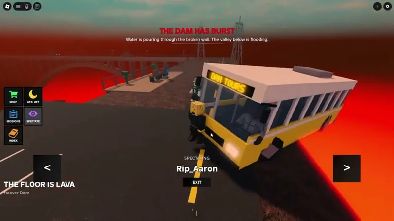
胡佛大坝道路上的黄色巴士位于发光熔岩上方,展示了熔岩灾害中的地形关系。
Do not follow a vehicle route just because it is visible. Check whether the hazard is cutting off the road and whether a nearby bridge, building, or higher surface gives you a safer alternative.
Storms, fire, and falling objects
For storms, fire, meteors, or falling debris, indoor space can be useful. The Hospital, Downtown, and City descriptions point to buildings and upper floors as possible shelter, but shelter is conditional: a damaged building is not safer merely because it is indoors.
Choose a sturdy-looking structure with more than one exit when possible. Avoid crowded low areas, exposed roads, and landmarks that are already shaking or burning. If the structure begins to fail, leave before the route disappears.
How to use landmarks without overcommitting
Landmarks are for orientation first and safety second. A Ferris wheel tells you that you are in or near Thrill Park; it does not prove that standing beneath it will survive the current disaster. A bridge gives you a route and a height reference; it does not guarantee that its supports or approach remain intact.
Use this decision order:
- Identify: match the map name and one visible landmark.
- Classify: decide whether the immediate threat is water, ground damage, collapse, fire, or falling objects.
- Choose: select the nearest suitable high, covered, or open route.
- Reserve: keep a second route toward another landmark or safer surface.
- Reassess: after a major change, check whether the ground, building, or crossing still exists.
This is more reliable than learning one route for every round because the same map can host different disaster simulations.
What the current map evidence does not confirm
The available records do not establish a complete list of official map names, spawn points, exact building floors, fixed safe zones, or universal route timings. City, Island, Downtown, Hospital, Bridge, and Lighthouse may describe environments or landmarks rather than separate formal maps in every context.
Video footage is useful for recognizing a moment in play, but a player’s spoken identification does not prove that a location is permanent or that the same route works in every round. Use the live map name and visible terrain as the final authority. This matters especially for Hoover Dam, where the evidence supports the dam-road and lava visual but not its full interaction rules.
Frequently asked questions
How do I identify a map in What If Disasters?
Check the map name when the countdown ends, then match visible landmarks. Thrill Park is especially recognizable by its Ferris wheel, central tall ride, Haunted house, tower, and streets.
What is the safest map location during a flood or tsunami?
Look for a nearby high option such as a bridge, lighthouse, upper floor, rooftop, or other elevated structure, and keep moving if the water continues to rise. The exact safe location depends on the round.
Is Thrill Park's tallest ride always safe?
No. The available Thrill Park record shows an earthquake cracking streets, separating areas, toppling a roadside tower, and collapsing about ten buildings. Height alone is not a complete earthquake strategy.
Are City, Island, Hospital, and Lighthouse official map names?
The supplied evidence mentions them as environments or landmarks, but it does not confirm a complete list of formal map names, spawn points, or fixed routes for every location.
Sources
- Public map reference: https://whatifdisasters.wiki/maps/what-if-disasters-thrill-park-map
- Reviewed: 2026-10-27